Where Our Fathers Left Off

Rabbi Yehudah Landy retraces ancient footsteps from the Jordan Valley to Beit She'an

Photos: Elchanan Kotler
Although the modern-day baking-hot town of Beit She’an is almost 100 percent Jewish, the ancient city was a center of pagan life in the Land of Israel, foremost among the Hellenistic city-states spread across the Roman Empire – its preserved remains like an eerie, open-air museum to the Roman way of life. Does that make it shemittah-free?
If Yerushalayim is the beating heart of Eretz Yisrael, then the Jordan Valley, whose red mountains fill the windscreen as we leave the capital behind, is the country’s spine.
While the cardiac analogy is actually a midrash that refers to the spiritual centrality of the Holy City, the latter comparison was a staple of early Israeli military thinking, not Chazal.
But drive north up Route 90 — at 480 kilometers, or 300 miles, Israel’s longest road — and the similarity is hard to miss.
For while the mountain ridge rising on the left, leads to Yehudah and Shomron in the country’s center, the east bank of the Jordan River on the right — today, the Hashemite Kingdom of Jordan — holds the second half of ancient Eretz Yisrael.
That insight, along with many others, is courtesy of my passenger and guide for the day, Rabbi Yehudah Landy. A noted author and expert on both Jewish history and gevulos ha’Aretz — determination of Eretz Yisrael’s halachic borders — Rabbi Landy is in a league of his own as a tour guide. Nothing compares to hearing a talmid chacham equally at home in the Talmud Yerushalmi and in archaeology.
As we head north under a Mediterranean-blue sky, it’s to tell the story of one of the most important “vertebrae” on the country’s backbone: the ancient town of Beit She’an, and its connection to shemittah.
Water Ways
The Beit Ha’aravah junction on Route 90, known as the “Kvish Habikah” (“valley highway”), is something out of a Marlboro advert.
The road from Jerusalem winds down past the Bedouin encampments, past the signs indicating the distance to sea level and suddenly arrives at a T-junction in the desert. One fork goes left, all the way to Metula on the Lebanese border, the other runs south to Eilat.
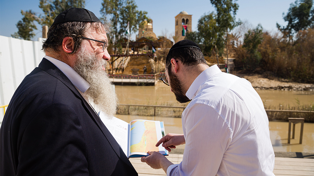
“Turn off here,” Rabbi Landy signals, two minutes after we’ve taken the left. “It’s one of the only national parks in Israel that has free entry, and it’s the place where the Jewish People crossed the Yarden when they entered Eretz Yisrael.”
Qas’r Al-Yahud — meaning “Fortress of the Jews” in Arabic — is the name of the site. A clutch of churches and flags belonging to various Christian orders signals the place’s theological importance to those groups, but what interests us is beneath the surface.
“There, under one of these churches,” says Rabbi Landy with a gesture, “are the twelve stones that Bnei Yisrael brought out of the Yarden when they crossed.”
The miraculous crossing of the Jordan — like its better-known cousin, Kri’as Yam Suf — was accomplished by splitting the waters. Tanach records how Yehoshua instructed twelve men to carry stones out of the petrified river to leave as an “eternal memorial” for the supernatural events.
These stones were placed at a place called Gilgal, “at the eastern end of Yericho,” where the nation camped after the crossing.
“Look across — here we are to the east of Jericho,” says Rabbi Landy. “But we know of the location from the Madaba Map, a sixth-century mosaic found in Jordan with inscriptions in Greek that shows that as late as 1400 years ago, those stones were still visible here.”
Madaba — called Meidva in the Torah — is itself testimony to the deep Jewish roots of the other side of the Jordan known as Eiver HaYarden.
Meidva was conquered from Sichon, king of the Emorites, by Moshe Rabbeinu, and changed hands repeatedly over the centuries as Jews and Moabites fought over it. It was conquered by Yochanan, who was Kohein Gadol and grandson of Mattisyahu, leader of the Chashmonaim.

Making an Entrance
In this rugged landscape, it’s not hard to picture a caravan of dust stained travelers, led by the 40,000 soldiers whom Tanach records crossed the Yarden, wonder-struck as the waters ceased flowing on Yehoshua’s approach.
The significance of the place is recorded in Shulchan Aruch as one of the places that has a special brachah commemorating the miracle that took place there, although since the stones are no longer visible, many don’t recite it.
The Jordan River itself, is far from a major waterway. Little more than a muddy looking stream, the Jordanian border guard on the opposite bank is well within hailing distance.
“Why was there any need for a miracle to split this river,” asks Rabbi Landy, “when they could have waded across?”
In answer, he points to a plaque, high on the steps that lead down to the river, indicating the point that floodwaters rose to in the winter of 2013. “Just a few years ago the river rose a few meters, climbing high on both banks.”
One of Rabbi Landy’s works — as yet only in Hebrew — is an exploration of Sefer Yehoshua, which melds Torah, historical, and archaeological sources about the period.
“Look, here is a picture of the Jordan River near the Allenby Bridge from the 1920s. The river is swollen massively. That’s why Sefer Yehoshua describes the river overflowing its banks during the harvest season, since they crossed in Nissan.”

Way Under
Heading north on Route 90 normally means contemplating the road’s combination of scenic beauty and danger.
Known as the “kvish hadamim,” it’s the country’s deadliest road due to the fact that it’s only one lane in each direction, and has no illumination at night.
But with Rabbi Landy in the cockpit, the landscape looks different.
“Imagine you were trying to get from the Jordan into the heartland of Eretz Yisrael,” he says. “You have to climb from the valley, up what is known as the ‘Gav HaHar’ — the eastern slopes of the mountain range that runs up through Yehudah and Shomron. That’s exactly what the Jewish People did after conquering Yericho. They headed up to Ai, which they only conquered after being beaten back on the first attempt.”
There is a debate about the location of Ai on modern maps. One suggestion is the ruin of Et-Tell, near Ramallah. In other words, Bnei Yisrael struck west 14 kilometers to leave Ai a smoking ruin, finding themselves in the center of today’s Israel, just miles from modern-day Modiin Illit.
In their progress inland, the massive caravan of desert travelers left behind a monument not mentioned in Tanach.
“Up there on the ridge,” Rabbi Landy points, “is a footprint-shaped structure of stone that’s so big, that the outline can only be seen from the air. It dates back to the 13th century BCE, which is when Am Yisrael crossed the Yarden. Excavations revealed kosher animal bones, which adds weight to the idea that it was left by the Jewish People. The site also corresponds to one of the routes that logically speaking, would have led from the Yarden.”
The monument is one of five, mapped by Adam Zertal, a Haifa University archaeologist who spent eleven years excavating the Har Ephraim region that overlooks the Jordan Valley.
“Despite the lack of any mention of the footprints in Torah sources, it’s possible that they’re a symbol of ownership, of acquiring Eretz Yisrael ‘wherever the sole of your foot treads,’ as Yehoshua says.”
Where does his unusual combination of Torah and historical scholarship come from? I ask as we drive.
The Landy family are direct descendants of the Vilna Gaon, who wrote of the seven branches of wisdom — including mathematics and music — that a talmid chacham should master. The Gaon was legendary for his mastery of the practical details of Torah knowledge.
“When I brought my sefer to Rav Michel Zilber, the rosh yeshivah of Z’vhil, he commented, ‘It’s because you’re descended from the Gra.’”
Whatever the truth of that genetic explanation, there were other more direct influences. Rabbi Landy’s own parents made aliyah from America when their son Yehudah was a young boy, where Landy senior — a talmid of Chaim Berlin turned chemist — worked in the Israeli patent office. Later, Rav Yoel Schwartz, a talmid chacham with an unusually broad range of interests reflected in the dozens of seforim he’s written, who taught Yehudah Landy in Yeshivas Itri, took bochurim on field trips around Israel to learn and explore.
That accumulation of Torah and history is brought to bear on another ancient ruin above us, high up in the hills.
“Sartaba,” explains Rabbi Landy, pointing to the ridge that looks down on the Jordan Valley. “It’s mentioned in the Mishnah in Rosh Hashanah as the place where a beacon would be lit, transmitting the news of kiddush hachodesh out to Babylonia.”
Also called Alexandrium, the fortress was constructed by the Chashmonaim as part of a string of outposts connecting Jerusalem and Scythopolis, the Greek name of our destination.

Sovereign Territory
As the signposts herald imminent arrival in Beit She’an, the weather changes abruptly. The clear blue skies of the Jordan Valley are replaced with thunderclouds in a clear sign that the area is a distinct microclimate.
Beit She’an’s meteorological uniqueness is a good metaphor for its distinct halachic status when it comes to shemittah, a fact that has generated debate from the times of the Mishnah to the present.
“According to the Yerushalmi, Rabi Yehudah Hanasi absolved Beit She’an from the laws of shemittah,” Rabbi Landy explains. “That’s because the area hadn’t been conquered and sanctified by the olei Bavel, the Jews who returned from the Babylonian Exile, the key parameter in halachic terms.”
Although modern-day Beit She’an, a baking hot, somnolent town of 19,000 inhabitants, is almost 100 percent Jewish, that is a post-1948 phenomenon.
For thousands of years, it was a center of pagan life in the north of the Land of Israel. Known in Roman times as Scythopolis, it was the foremost among a group of Hellenistic city-states known as the Decapolis, spread across the eastern frontier of the Roman Empire from modern-day Syria to Jordan.
Geography made this location at the crossroads of the Jordan Valley and the Jezreel Valley a natural place for a commercial center to develop.
If the Jordan Valley is the spine of the ancient Land of Israel, then Beit She’an sits atop the country’s shoulder blades.
“If you want to cross the Jordan Valley, say from Mesopotamia in the northeast to Egypt in the southwest,” Rabbi Landy explains, “the easiest place is at Beit She’an, because it’s flat. This town was astride the ancient route known sometimes as the Via Maris — Way of the Sea — or Derech Pelishtim.”
The gentle climb out of the Jordan Valley was the reason that under the Ottomans, Beit She’an became a stop on the Jezreel Valley railway to Haifa, a spur on the Hejaz railway connecting Damascus to Medina in Saudi Arabia.
With the warming of Israeli-Saudi relations, there is talk of reviving those rail links, connecting the Gulf and Mediterranean in an initiative that’s been dubbed the “Peace Railway.”
Beit She’an’s pagan identity was interrupted by the Chashmonaim, who conquered and expelled the inhabitants in the 2nd century BCE.
In the words of Megillas Taanis, a Mishnaic-era compilation of special days for the Jewish People that is quoted by the Gemara, on “the 15th and 16th of Sivan, the men of Beit She’an and the valley were exiled.”
“Yochanan Hyrkanos, a second-generation Chashmonai who created the Hasmonean state, didn’t populate the city with Jews,” explains Rabbi Landy, “so that’s why it didn’t attain kedushah, which in turn meant that in terms of shemittah, it remained outside Eretz Yisrael.”

When in Rome
At the foot of a dramatic tel, or archaeological hill, ancient Beit She’an is like an eerie, open-air museum to the Roman way of life.
Its central boulevard — built with the curvature necessary to drain off the rainwater to the sides — consists of towering classical columns on both sides, some with intricately carved capitals, a Greek art form perfected by the Romans.
The store fronts are on either side of this main street. At one end is a temple for the pantheon of Roman gods, and further along is the theater. On a side street is a beautifully preserved bathhouse.
An earthquake toppled massive pieces of masonry in 747 CE, but even two millennia later, the power and grandeur of Rome radiate from these ruins. The weather-scarred remains testify to the challenge posed to the Jewish way of life by the Hellenic and Roman invaders.
The city as it lies before us was the one that Rabi Yehuda Hanasi, who lived at the time in Beit She’arim, about 50 kilometers to the east, would have seen.
It’s in settings like these, that the Gemara comments on various aspects of Roman life, including that famous innovation, the bathhouse.
The example preserved in Beit She’an reveals the engineering prowess of the Roman world. A set of cone-like pillars of various heights built into the floor turns out to be an ingenious system of under-floor heating.
Hot air from furnaces in the side of the building was piped in to the gap created by two levels of floor built on the cones. This Roman shvitz would have been key to public hygiene as well as a central clearing office for news and business.
It was also, according to the Gemara, a dangerous place to be when it was new. “We’re told that the bathhouses could be a makom sakanah,” says Rabbi Landy, “and if you imagine these under-floor heating layers collapsing with people inside the bathhouse, you can understand why.”
Whether this particular example suffered from these defects is unknown, but the advanced design of the bathhouse on display is an example of the fact that the Romans were far more sophisticated in many areas than the civilizations that came after their collapse.
A well-known example of this disparity lies on the other side of the country, in Caesarea. That city’s port was built by King Herod using Roman technology. Massively built, it lasted for 1,500 years until succumbing to the waves in early Ottoman times. But such was the sophistication of the Roman design that the Turks couldn’t replicate it centuries later.
On the other side of Beit She’an’s Main Street is another central institution in Roman times — the theater.
“The Gemara calls Roman theaters ‘moshav leitzim’ — a place of irreverence and mockery. It’s in places like these,” says Rabbi Landy gesturing down to the stage from the stands of the theater, “that the Romans spread their worldview. Remember that before the written word became mass media with the printing press, theaters were a major way for disseminating ideas.”
One play that might have been performed in the Beit She’an theater is recorded by the Midrash in Eichah, and highlights the fact that the Romans mocked the observance of shemittah.
“They bring camels clad in rags,” says the Midrash, “and the actors ask each other, ‘Why is this one mourning?’ and they answer, ‘These Jews observe shemittah and they have no vegetables, so they eat the camel’s thorns, and that’s why it’s mourning.’ ”

What’s in a Name
Over the centuries that followed the zenith of its influence, Beit She’an was reduced to a dusty backwater, its Roman glories lying wherever the earthquake left them.
But the city’s name is tied to a figure from the time of the French Rishonim, who was essentially the father of the historiography and archaeology of Eretz Yisrael.
Known to posterity as the Kaftor Va’ferach after his work by that title on agricultural halachah, Rabbi Ishtori HaParchi was born in Provence, southern France, in 1280, a descendant of a distinguished rabbinic family.
In 1306, France’s King Philip IV (known as “the Fair” — for his looks, not his behavior) expelled the country’s Jews, and so the young scholar made his way to Eretz Yisrael via Spain and Egypt.
He settled first in Yerushalayim, but left when the Holy City was split by the dispute over the Rambam’s work that divided Jewish communities worldwide.
He headed for Beit She’an, where he practiced medicine and used it as his base for an epic one-man mapping mission of the Holy Land.
“The Kaftor Va’ferach spent five years traveling around Yehudah — the central portion of the country around Yerushalayim — and two more in the rest of the country. Based on conversations with the Arab inhabitants, and their names for different villages and areas, he attempted to establish the location of many of the sites across Eretz Yisrael.”
Rabbi Ishtori HaParchi’s methods proved accurate in many cases, such as establishing the location of Megiddo, where King Yoshiyahu died in battle at the hands of Pharaoh Necho.
But the method of establishing locations based on traditional names — especially when it affects halachic matters — has been controversial. The Chazon Ish, for example, ruled that modern names aren’t decisive factors, given that settlements — even ancient cities like Beit She’an — can move and be renamed.
That dispute took center stage with the renewed Jewish settlement in the country in the 19th century. When the nascent Yishuv — essentially a handful of tiny agricultural enterprises — encountered shemittah for the first time, the suggestion arose that the fertile area of Beit She’an was the perfect solution.
“Rabbi Yitzchak Goldhar, author of a work on halachic geography called Admas Kodesh, suggested that the total area exempted by Rabi Yehudah Hanasi was 213 square kilometers — enough land to feed the population during shemittah. But his opinion wasn’t accepted, because he drew the borders too extensively, and he relied on the Arab place names, which have no validity in halachah. In practice, today there’s no leniency regarding shemittah in Beit She’an.”

Wall Posters
About three kilometers south of the ancient ruins of Beit She’an — and a welcome respite from the heat in the air-conditioned car — is a far more modern institution, Kibbutz Ein HaNetziv. Founded in 1946 by religious immigrants from Germany, it was named after Rav Naftali Tzvi Yehudah Berlin, the Netziv of Volozhin.
Surrounded by the green lawns and humble buildings typical of kibbutzim everywhere is an expansive shul. In front of the one story building, is a reproduction of one of the wonders of Israeli Biblical archaeology, the Rechov Mosaic.
Discovered in 1973 by farmers working on the kibbutz’s land, the mosaic is the oldest known Talmudic text. It lists those fruit and vegetables that are forbidden in Beit She’an during shemittah due to the fact that they are grown inside Eretz Yisrael proper.
“Shalom. These fruits are forbidden in Beit She’an during the Seventh Year, but during other years of the seven-year cycle they are tithed as demai-produce: cucumbers, watermelons, muskmelons, parsnip (carrots), mint that is bound by itself.”
The large mosaic then quotes almost word-for-word, a segment of Talmud Yerushalmi that delineates the parts of Israel conquered by those returning from Babylon.
“The mosaic was originally on the wall of a shul in the area that collapsed in an earthquake,” explains Rabbi Landy. “The professor from Bar-Ilan University who excavated it commented that it was of such authenticity that any source that differed should be regarded as like chometz on Pesach!”
The 29 terse lines are written in the kesav Ivri script used in the times of the Gemara, and the mosaic itself contains no artistic flourishes — it’s pure halachic functionality.
The produce listed in the mosaic contains many items that would make it onto a modern grocery list. “Already in Roman times, their diet was similar to ours, minus citrus fruit, which came into the country via the Arabs later.”
Beyond the practicalities, the mosaic is moving evidence that the ancient Jews of this area led Torah lives very much like our own.
They had a shul, and this mosaic was their equivalent of a sign hung by the local beis din giving up-to-date halachic guidance for a society that was very agrarian.
A late afternoon breeze wafts across the kibbutz as we stop outside the shul to inspect another of the archaeological treasures that the local farmers have dug up.
“These are agricultural tools mentioned in the Gemara,” says Rabbi Landy. “See here the upper and lower millstones were called the ‘shechev’ and ‘rechev.’
“We sit on top of such a wealth of archaeological findings that shed light on Torah,” he says. “Imagine if our teaching of Gemara were informed by students seeing this, or if Sefer Yehoshua could be taught while seeing the evidence of the Jewish People’s journey across the Yarden.”
Back in the car, it’s only a few minutes to Route 90, and ancient Eretz Yisrael’s spine. Along the way, windblown “Here We’re Keeping Shemittah” signs testify to the fact that many of the farmers en route have downed tools for a year’s rest.
While they struggle through a few more months of financial uncertainty, the agricultural tools and weather-beaten mosaics left behind by the ancient farmers of Israel’s northern breadbasket are a reminder that in Jewish terms, we’re just picking up where our forefathers left off.
(Originally featured in Mishpacha, Issue 919)
Oops! We could not locate your form.
RELATED CONTENT

A significant percentage of the factory’s output is kosher l’mehadrin, known to chocolate lovers in the frum world as Schmerling’s

The world’s largest collection has 8,500 of them. Which Haggadah are you going to use this Pesach?


Today Avivi Shifris's groggers turn up for children all over — because he was once just like them


Reb Ahron Hoberman embraces a unique, ageless art, finding deeper meaning amid a striking light show